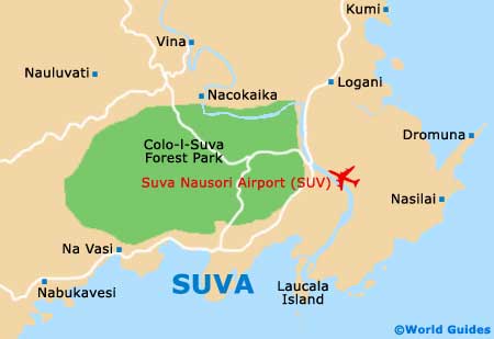
Suva Nausori International Airport (SUV)
Orientation and Maps
(Suva, Fiji)
Sited on the south-eastern shoreline on Viti Levu, Fiji's biggest island, the city of Suva has a population of around 80,000 residents. Fiji's main centre of industry, commerce and politics, Suva is also home to a busy harbour. Enjoying an impressive peninsula setting, Suva may be a coastal city, but the closest beach is more than 40 km / 25 miles away. Historically, much of central Suva was once mangrove swamp and this land has been gradually reclaimed over the years.
Fiji's number two airport, Suva Nausori Airport (SUV) is located on the north-eastern side of the city and is currently undergoing considerable renovation and improvement. This important gateway to the island is often known locally as Luvuluvu.
Suva Nausori Airport (SUV) Maps: Important City Districts
Around the city, the main landmarks include the Suva Central building, which is the country's highest structure. Suva's Reserve Bank of Fiji Building is also a major high-rise building and dates back to the early 1980s. Nearby are a surprising number of public parklands, with the historic Thurston Gardens being amongst the best. Apted Park is also popular and known for its spectacular sunsets.
The area surrounding the campus of the city's University of the South Pacific (USP) is a particularly youthful district. With more than 16,000 students, the university also has further faculties at other countries in Oceania.
Fiji Map

Suva Map